Trail Walking La Chapelle-Longueville - Saint Just - Les coteaux de Seine - Photo

Saint Just - Les coteaux de Seine

 marcel.F
marcel.F

User

© OpenStreetMap contributors
Length
Length
10.5 km
Max alt
Max alt
147 m
Uphill gradient
Uphill gradient
247 m
Km-Effort
Km-Effort  
13.8 km
Min alt
Min alt
18 m
Downhill gradient
Downhill gradient
244 m
Boucle
Boucle
Yes
Creation date :
2019-04-01 20:25:43.46
Updated on :
2019-04-18 08:04:53.041

(4 Reviews)

Walking
Walking
2h57
Difficulty : Easy

Scan this QR Code to open this trail in the SityTrail application

FREE GPS app for hiking

Logo SityTrail SityTrail

IGN / Geographical institutes

Download SityTrail from the App Store Download SityTrail from Google Play

Logo SityTrail SityTrail World

The world is yours!

Download SityTrail from the App Store Download SityTrail from Google Play Download SityTrail on Huawei AppGallery

About

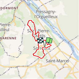
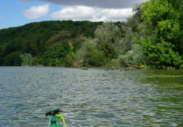
Trail Walking of 10.5 km to be discovered at Normandy, Eure, La Chapelle-Longueville. This trail is proposed by marcel.F.

Description

Boucle au départ de l'église de Saint Just
boucle homologuée CAPE avec balisage jaune

Elevation profile

Positioning

Country:
France
Region :
Normandy
Department/Province :
Eure
Municipality :
La Chapelle-Longueville
Location:
Unknown
Start:(UTM)
386194 ; 5440666 (31U) N.

Comments

Please log in to post a review or rate the element


excellent


Trails nearby

Trail Walking Vernon - Les falaises de Seine de Vernon à Mantes la Jolie - Photo
Walking
chessyca

Walking

Difficult
Vernon, Normandy, Eure, France
37 km | 47 km-effort
7h 38min
No
Trail Walking Saint-Pierre-de-Bailleul - A la rencontre des lavoirs - Photo
Walking
Fky78

Walking

Medium
Saint-Pierre-de-Bailleul, Normandy, Eure, France
9.9 km | 12.6 km-effort
2h 50min
Yes
Trail Mountain bike Vernon - Les prés de Vernonnet - Vernon - Photo
Mountain bike
tracegps

Mountain bike

Easy
Vernon, Normandy, Eure, France
3.3 km | 3.7 km-effort
19min
Yes
Trail Walking Vernon - Les prés de Vernonnet - Vernon - Photo
Walking
tracegps

Walking

Easy
Vernon, Normandy, Eure, France
3.3 km | 3.7 km-effort
49min
Yes
Trail Walking Vernon - Entre musée et château - Vernon - Photo
Walking
tracegps

Walking

Easy
Vernon, Normandy, Eure, France
7.7 km | 9.6 km-effort
2h 0min
Yes
Trail Walking Vernon - Randonnée entre Seine et Forêt - Vernon - Photo
Walking
tracegps

Walking

Easy
Vernon, Normandy, Eure, France
7.7 km | 9.5 km-effort
2h 0min
Yes
Trail Mountain bike Vernon - Circuit de la Colline aux oiseaux - Vernon - Photo
Mountain bike
tracegps

Mountain bike

Easy
Vernon, Normandy, Eure, France
5.9 km | 7.3 km-effort
30min
Yes
Trail Walking Vernon - Circuit de la Colline aux oiseaux - Vernon - Photo
Walking
tracegps

Walking

Easy
Vernon, Normandy, Eure, France
5.9 km | 7.3 km-effort
1h 0min
Yes
Trail Mountain bike Vernon - Les Carrières - Vernon - Photo
Mountain bike
tracegps

Mountain bike

Easy
Vernon, Normandy, Eure, France
4 km | 5.4 km-effort
30min
Yes


Close
My subscriptions